Species Diversity and Community Assembly of the Vegetation of Mankial Valley, District Swat
-
Hayat Ullah
Department of Botany, Hazara University Mansehra, Pakistan
Zafar IqbalDepartment of Botany, Government Degree College, Battagram, Pakistan
Faizul Haq
Department of Botany, Government Degree College, Battagram, Pakistan
| Received 11 Jan, 2023 |
Accepted 30 May, 2024 |
Published 30 Sep, 2024 |
Background and Objective: Phytosociological studies explain and communicate the distribution of different plant communities with ecological factors in a particular zone, which give consequent results to scientific and practical proposals for improvement of the studied area. This study was designed to explore the species diversity, plant communities and relationship of different plant species with the environmental variables. Materials and Methods: The study area was surveyed to identify the different stands of vegetation based on habitats and physiognomy of vegetation by using the line transect method. The GPS and clinometer were used for recording the physiographic factors like slope exposure, angle of slope, elevation, latitude and longitude. Soil samples at 15 cm depth were collected from each stand and were analyzed for soil texture, water holding capacity, EC, N2, P, K, Mg and Na. The TWINSPAN analysis was used to classify the vegetation into plant communities. Results: From 15 stands 153 plant species belonging to 110 genera and 56 families were recorded. The leading family was Asteraceae with 20 species. Therophytes were the dominant life-form with 41.45%, followed by Chamaephytes with 15.79%. The dominant leaf spectrum was microphylls with 32.24%. Two Way Indicator Species Analysis (TWINSPAN) classified the vegetation into 5 plant communities. Conclusion: It was perceived that mostly north-facing slopes have higher numbers of communities than south-facing slopes. There was a close relationship between physiographic factors and vegetation. Anthropogenic and biotic disturbances cause degradation of pastures and affect the natural biodiversity. Therefore, sustainable use of natural resources and conservation is necessary in order to preserve biodiversity for future use.
| Copyright © 2024 Ullah et al. This is an open-access article distributed under the Creative Commons Attribution License, which permits unrestricted use, distribution, and reproduction in any medium, provided the original work is properly cited. |
INTRODUCTION
Mankial Valley is located at an elevation of 5,600-17,000 ft above sea level and it lies at Latitudes of N = 35°12’.241” and Longitude E = 72°32’.151’’. The highest mountain peak in the area is Koh-i-Shaheen known as SookoSar at an elevation of 5726 m from sea level1. Important rivers of the area are Serai River flowing in Serai sub-valley while Mankial River flows in Mashkoon and Jabba sub-valleys, which meet at Badai and finally enter into river Swat at main Mankial village. Climatically the area has usually moist temperate types of forests. The valleys have high snowfall for about four months. During March and April, high rainfall occurs, while summer as well as autumn are relatively drier seasons of the year. Mean annual maximum temperature is 61.9°F, minimum temperature is 39.37°F, snowfall is 331.01 cm and annual rainfall is 52.43 cm2. The vegetation of the area extends from a moist temperate climate to sub-alpine and alpine pasture3. The mountains of the area lie in Hindu-raj series of Hindu-Kush ranges. However, due to climatic and vegetation similarity with Himalayan ranges named as Trans-Himalayas4. The area shows a distinguishing location in Swat region due to its geographical linking with Hindu-Kush mountains series, Himalaya region and Karakorum ranges5.
The quantitative study of vegetation in a particular area is known as phytosociology and its principal aim is to explain the arrangement and classification of various plant species in an important way6. Phytosociological study is concerned with the knowledge of floristic composition, structure of vegetation, growth and its division in a specific region, while in relation to ecology, it cannot be restricted to a specific habitat7. Phytosociologists naturally related to recording a complete description and classification of vegetation structure in a specific geographical region8. For studying a specific vegetation according to an ecological point of view, the first step would be to explain the facts as they reside on the ground surface e.g. vegetation and its habitat. In phytosociology main purpose is to associate different plant species for sampling performance related to floristic composition which makes plant association. In a new method, it’s named eco-phytosociology9,10.
Vegetation ecology shows the determination of species composition and sociological relationships of species in various communities. Through phytosociological and ecological studies we are able to explain and communicate the distribution of different plant communities with ecological factors in a particular zone, which gives consequent results to scientific and practical proposals for improvement of the studied area11,12.
This study was designed to explore the plant diversity, plant communities and relationship of different plant species with the environmental variables of the Mankial Valley because no work has been done previously on this aspect.
MATERIALS AND METHODS
Initially the study area was surveyed to identify the different stands of vegetation on the basis of different habitats and physiognomy of vegetation during 2020-21. The whole study area was divided into 15 different stands. The vegetation structure of different stands in the study area was investigated by applying the 50 m line transect method to record the phytosociological attributes which are very important and authentic technique for a survey of the plants10. For a sampling of vegetation, different numbers of transects were applied randomly according to the size of the stand to take the representative data. About 3 to 4 transects were taken for each stand. Phytosociological attributes like plant density, relative density, canopy cover, relative cover, frequency and relative frequency were recorded by using the process described by Dombois and Ellenberg13. The GPS and clinometer were used for recording the physiographic factors like slope exposure, angle of slope, elevation, latitude and longitude. Digital camera was used to photograph the plant species during fieldwork. Life form and leaf spectra were determined and classified according to Raunkiaer14 classification. Different phytosociological parameters like density, cover, frequency, relative density, relative cover and relative frequency for each species were calculated15,16.
Soil samples at 15 cm depth were collected from each stand, mixed well stored in polythene bags and labeled. The physical and chemical properties of each soil sample were analyzed in the laboratory of ARI (Agricultural Research Institute) Mingora, Swat. The soil texture and water holding capacity were calculated. Electrical conductivity of soil was measured by using Consort-K520, a digital conductivity meter. The total nitrogen and phosphorus content in soil were analyzed17,18. Potassium (K), Magnesium (Mg) and Sodium (Na) contents in the soil were analyzed through flame photometry technique19.
Statistical analysis: Statistical analysis was carried out by using PC-ORD software version 6. The importance value index was further analyzed through TWINSPAN classification10.
RESULTS
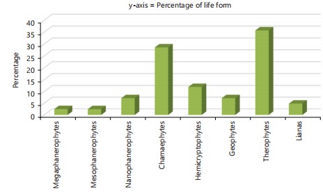
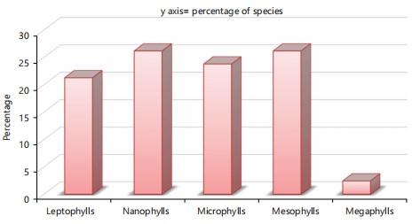
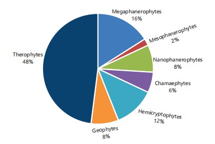
The area consists of 153 plant species belonging to 110 genera and 56 families. Asteraceae was the dominant family with 20 plant species, followed by Lamiaceae and Rosaceae comprised of 10 plant species each. The results indicate that the dominant life form was Therophytes at 41.45%, followed by Chamaephytes at 15.79%, Hemicryptophytes with 12%, Nanophanerophyts at 10%, Geophytes and Megaphanerophytes at 8% plant species each, Lianas with 3% and Mesophanerophytes with 2% plant species. Dominant leaf spectrum was microphylls at 33%, followed by nanophylls at 32.24%, mesophyll at 18.42%, megaphylls at 3.29% and leptophylls contributed 13.16% of plant species (Table 1).
TWINSPANS classification: The IVI data of 153 plant species and 15 stands were analyzed by TWINSPANS classification and 5 different plant communities were recognized in the study area (Fig. 1). These communities are described below.
Clematis-Thymus-Rhododendron (CTR) community: Clemetis-thymus-rhododendron community was recorded at an Altitude of 10791-11808 ft. The community was found at Sar Banda in alpine region. The longitude ranges from (E =72°38.700’ to 72°38.975') and latitudes from (N = 35°17.487’ to 35°17.731') at SE, NE, N and S exposure. The community was comprised of 41 species of which 28 were herbs, 12 shrubs, 3 trees and 2 species each of ferns and grasses. In this community, the leading species was Clematis connata, followed by Thymus linearis and Rhododendron arboreum.
The dominant life form in the community was Therophytes with 35.71% (Fig. 2). The dominant leaf spectra were nanophylls with 26.19%, (Fig. 3). Soil chemistry reveals that this community exists in loamy sandy soil, pH (5.5-6), soil organic matter (1.656-3.79), nitrogen content (0.0828-0.18759), phosphorus (5.55-6.07), potassium (40-50) and electric conductivity (0.049-0.091).
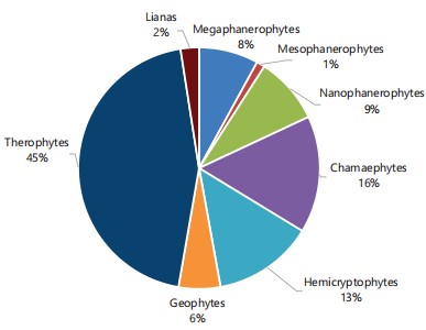
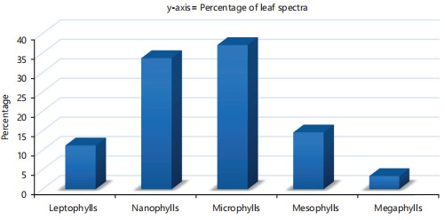
Quercus-Indigofera-Plectrantha (QIP) community: At an elevation of 6441-6975 ft Quercus-Indigofera-Plectrantha community was recorded in Mankial and Badai. The Longitude is 072°37’.209”-072°36’.929” and Latitude 35°19’.534”-35°19’.374” exist at NW, SE and W slope facing. A total of 91 plant species were recorded of which 70 plant species were herbs, 9 plant species were shrubs, 8 were tree species and one species of fern and climber each. Dominant species was Quercus dilatata, followed by Indigofera heterantha and Plectranthus rugosus.
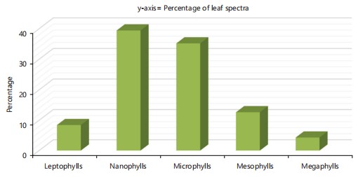
The dominant life form class was Therophytes with 45%, followed by Chamaephytes with 16% (Fig. 4). Microphylls (37.07%) dominated in this community, followed by nanophylls with 33.70% (Fig. 5). Physico-chemical analysis of soil indicated that this community existed in loam and loamy sandy soil with pH (5.2-5.4), soil organic matter (6.07-6.21), nitrogen content (0.3036-0.3105), soil phosphorus content (6.027-7.59), potassium content (226–240) and electrical conductivity was 0.196-0.151.
| Table 1: | Life form and leaf spectra of plant species | |||
| Life form | Species | Percentage | Leaf spectra | Species | Percentage |
| Megaphanerophytes | 12 | 7.89 | Leptophylls | 20 | 13.16 |
| Mesophanerophytes | 3 | 1.97 | Nanophylls | 49 | 32.24 |
| Nanophanerophytes | 15 | 9.87 | Microphylls | 50 | 32.89 |
| Chamaephytes | 24 | 15.79 | Mesophylls | 28 | 18.42 |
| Hemicryptophytes | 18 | 11.84 | Megaphylls | 5 | 3.29 |
| Geophytes | 12 | 7.89 | |||
| Therophytes | 63 | 41.45 | |||
| Lianas | 5 | 3.29 |

|
|
Cedrus-Indigofera-Aegopodium (CIA) community: Cedrus-Indigofera-Aegopodium community was found at an elevation range of 6179-7114 ft in Bair, Serai, Main serai and soro badai localities with 072°38.258’ to 072°39.484’ E and 35°19.774’ to 35°20.396’ N, slope exposures towards North, South-East and North-West with 30°35° slope angles. A total of 71 plant species were recorded in the community of which 57 were herbs and 7 were shrubs and trees each.
The dominant species were recorded as Cedrus deodara, Indigofera heterantha and Aegopodium burtii. Therophytes were dominant with 49.30%, followed by Hemicryptophytes (14.08%), (Fig. 6). Dominant leaf spectra were nanophylls with 39.44% (Fig. 7).
The results of soil chemistry revealed that the community was present in loamy sandy soil having pH (6-6.5), organic matter (5.52-1.656), nitrogen contents (0.256-0.3105), phosphorus (6.802-6.21), potassium content (112-248) and value of electrical conductivity ranges 0.598-0.438.
|
|
|

|
|
Cedrus-Sorbaria-Sambucus (CSS) community: Cedrus-Sorbaria-Sambucus community was observed at 7700 to 8250 ft altitude in Banr Banda, Myashgan, Myashtun and Neembanda of Mankial. It lies in 72°40’.124”-72°38’.893” E and 35°20’.624”-35°99’.067” N with North-East, North-West and North-facing slopes having 22-32° slope angles. As 50 plant species were recorded in the community including 34 herbs species, 6 shrubs, 9 trees and one species of fern.
Cedrus deodara was dominant plant species in the community, followed by Sorbaria tomentosa and Sambucus wightiana. The IVI contribution of herbs was 114.33, followed by shrubs (86.22), trees (110.76) and ferns (1.82). The leading life form class in the community was Therophytes with 48% (Fig. 8). Dominant leaf spectra were microphylls (34%) (Fig. 9).
Physico-chemical analysis of soil showed that community was established at loam and loamy sandy soil having pH (5.6-6.2), soil organic matter (2.07-6.762), nitrogen content (0.1035-0.3381), total phosphorus contents (7.39-7.85), potassium content (76-168) and electrical conductivity was 0.11-0.237.
Cedrus-Asplenium-Pinus (CAP) community: The Cedrus-Asplenium-Pinus community was recorded from 6613-6500 ft elevation at Oosh locality lies in 72°38’.604” E and 35°19’.686” N with North-West facing and 30° slope angle. The community comprised 38 plant species of which 25 were herb species, 5 shrubs and 1 specie each of fern and grasses.
|

|
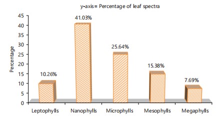
The dominant plant species was Cedrus deodara followed by Asplenium trichomanes and Pinus wallichiana. The leading life form class in the community was Therophytes with 38.46%, followed by Hemicryptophytes with 20.51% (Fig. 10). The dominant leaf spectra was nanophylls with 41.03%, followed by microphylls having 25.64% (Fig. 11).
Physico-chemical analysis of soil indicated that community has loam and loamy sandy soil with pH 5.8, organic matter (6.693), nitrogen content (0.33465), phosphorus (6.144), potash content (18) and electrical conductivity was 0.10.
Index of similarity and dissimilarity: The maximum value of similarity index was found between Cedrus-Indigofera-Aegopodium and Cedrus-Sorbaria-Sambucus communities which were 61.15%, followed by Quercus-indigofera-Plectranthus and Cedrus-Indigofera-Aegopodium communities with 53.08% and lowest value of similarity index was found between Clemetis-Thymus-Rhododendron and Cedrus-Sorbaria-Sambucus communities with 6.59%.

|
| Table 2: | Similarity and dissimilarities of communities in Mankial Valley | |||
| Communities | Clematis, Thymus, Rhododendron |
Quercus, Indigofera, Plectrantha |
Cedrus, Indigofera, Aegopodium |
Cedrus, Sorbaria, Sambucus |
Cedrus, Asplenium, Pinus |
| Clematis, Thymus, Rhododendron | - | 18.18 | 12.5 | 6.59 | 15 |
| Quercus, Indigofera, Plectrantha | 81.2 | - | 53.08 | 43.97 | 44.61 |
| Cedrus, Indigofera, Aegopodium | 87.5 | 46.91 | - | 61.157 | 47.27 |
| Cedrus, Sorbaria, Sambucus | 93.41 | 56.02 | 38.85 | - | 51.68 |
| Cedrus, Asplenium, Pinus | 85 | 55.38 | 52.72 | 48.31 | - |
For dissimilarity index, the maximum value was found between Clematis-Thymus-Rhododendron and Cedrus-Sorbaria-Sambucus communities with 93.41%, followed by Cedrus-Indigofera-Aegopodium and Clematis-Thymus-Rhododendron communities with 87.50% and the lowest dissimilarity index was found between Cedrus-Indigofera-Aegopodium and Cedrus-Sorbaria-Sambucus communities with 38.85% (Table 2).
DISCUSSION
This study comprised of 153 plant species belonging 110 genera and 56 families. Asteraceae was the leading family, followed by Lamiaceae and Rosacea. Current results were in line with Gentry and Dodson20 who worked on tropical rainforest and Ecuador areas, they observed that these families were dominantly presented in their respective areas.
The dominant lifeform class of the study area were Therophytes, followed Chamaephytes and Hemicryptophytes. The present findings are in agreement with Zeb et al.5 they reported that Therophytes were dominant followed by Chamaephytes and Hemicryptophytes.
The dominant leaf spectra were microphylls, followed by nanophylls and mesophylls. Haq et al.21 worked on Battagram District and reported that microphylls were dominant followed by nanophylls and mesophylls. Vegetation structure of Mankial Valley showed that a total of 5 different plant communities were established by using TWINSPAN classification. Our findings are similar to Haq et al.22 who worked on the vegetation of Nandiar Valley.
The co-efficient index of Sorenson similarity wholly depends upon the amount and importance numbers of common species sharing between the two communities23,24. The present study investigated that similarity and dissimilarity between communities depend on presence and absence of species in vegetation samples, all the communities have less than a 65% similarity index.
Altitude is an important factor for the determination of a specific type of vegetation. The variations in altitude cause changes in floristic composition along with community25.
Vegetation distribution is highly correlated with the variations in the soil’s physical and chemical characteristics. It was recorded that edaphic factors play an important role in community formation and vegetation composition in Mankial Valley. The findings of Rahim et al.26, support our results. They explained that physical and chemical properties of soil affect vegetation distribution. The present investigation created baseline data on the species diversity and vegetation structure of the study area. Changes in the habitat all over the world due to anthropogenic activities create a severe impact on biodiversity. Habitat exploitation of human beings should be reduced in order to maintain the plant communities. The data acquired through the present study serves to be imperative in the development of future conservation and management programs, which will recognize precedence areas for the long-standing persistence of plant communities. Besides above-ground biomass and diversity, attention should also be directed to sorting ecological processes in regional forest ecology and management. A focus should be placed on comparing the contributions of subterranean species in climax communities and other communities to the species diversity pattern and community assembly of above-ground vegetation communities.
CONCLUSION
Present study shows that the Mankial Valley is floristically rich. During rainy seasons frequency and species diversity were maximum due to sustainable environmental conditions. The diversity of species is decreases with an increase in altitude. The pH, slope angle, slope exposure and soil electrical conductivity directly affect the distribution of plant communities. Deforestation, overgrazing, soil erosion and medicinal plants collection were the main reasons for elimination of vegetation. Many plant species like Betula utilis etc. are decreasing due to extensive use by the local people and special attention is needed for their conservation. Unfortunately, biodiversity of the area is diminishing at a disturbing rate. Therefore, conservation of biodiversity is necessary in the study area.
SIGNIFICANCE STATEMENT
The present study discovered the species diversity and community structure of the vegetation of Mankial Valley. The result showed that the area is floristically rich. Species diversity increases during spring and summer seasons due to favorable environments and high growth rates and declines during autumn and winter seasons due to dry and drought conditions. The diversity of species decreases with an increase in altitude. Deforestation, overgrazing, soil erosion and pull-up of medicinal plants were the main reasons for elimination of vegetation. Many plant species were decreasing in the area such as Betula utilis due to extensive uses by the local people and special attention is needed for their conservation. This study will help the researchers to find out the species under threat and to make a strategy for biodiversity conservation.
REFERENCES
- Hamayun, M., M.A. Khan and S. Begum, 2003. Marketing of medicinal plants of Utror-Gabral Valleys, Swat, Pakistan. Ethnobotanical Leafl., 2003.
- Asim, Z.I., F. Haq and A. Iqbal, 2016. Phenology, life form and leaf spectra of the vegetation of Kokaraivalley, District Swat. J. Biodivers. Environ. Sci., 9: 23-31.
- Faizul Haq, H. Ahmad, Rahat Ullah and Z. Iqbal, 2012. Species diversity and ethno botanical classes of the flora of Allai Valley District Battagram Pakistan. Int. J. Plant Res., 2: 111-123.
- Abbas, F.I., T. Akhtar and A. Mian, 2009. Phytosociological analysis within the range of grey goral in Pakistan and Azad Kashmir. Pak. J. Bot., 41: 667-682.
- Zeb, A., Z. Iqbal, S.M. Khan, Inayat Ur Rahman and Faizul Haq et al., 2020. Species diversity, biological spectrum and phenological behaviour of vegetation of Biha Valley (Swat), Pakistan. Acta Ecol. Sin., 40: 190-196.
- Ilorkar, V.M. and P.K. Khatri, 2003. Phytosociological study of Navegaon National Park, (Maharashtra). Indian For., 129: 377-387.
- Haq, F., 2017. Morpho-anatomical description of Lygodium hazaricum Haq a new contribution to the fern flora of Pakistan. Trop. Plant Res., 4: 358-362.
- Singh, J.S. and S.P. Singh, 1987. Forest vegetation of the Himalaya. Bot. Rev., 53: 80-192.
- Faizul Haq, M. Irfan and C.R. Fraser-Jenkins, 2022. Multivariate statistical analysis of the pteridophytic diversity of District Battagram, Khyber Pakhtunkhwa, Pakistan. Ecol. Sin., 42: 322-331.
- Haq, F., H. Ahmad, Z. Iqbal, M. Alam and A. Aksoy, 2017. Multivariate approach to the classification and ordination of the forest ecosystem of Nandiar Valley Western Himalayas. Ecol. Indic., 80: 232-241.
- Haq, F., 2020. Ecological gradient analysis and community structure of macrofungi in different climatic zones of Western Himalayas, Pakistan. J. Biol. Environ. Sci., 16: 72-82.
- Gerhardt, F. and D.R. Foster, 2002. Physiographical and historical effects on forest vegetation in Central New England, USA. J. Biogeogr., 29: 1421-1437.
- Mueller-Dombois, D. and H. Ellenberg, 1974. Aims and Method of vegetation Ecology. Wiley, Hoboken, New Jersey, ISBN: 9780471622901, Pages: 547.
- Raunkiaer, C., 1934. The Life Forms of Plants and Statistical Plant Geography. Clarendon Press Oxford, London, United Kingdom, Pages: 632.
- Kitayama, K. and S.I. Aiba, 2002. Ecosystem structure and productivity of tropical rain forests along altitudinal gradients with contrasting soil phosphorus pools on Mount Kinabalu, Borneo. J. Ecol., 90: 37-51.
- Hussain, F., 1989. Field and Laboratory Manual of Plant Ecology. National Academy of Higher Education, Islamabad, Pakistan, Pages: 422.
- Hussain, F., S.M. Shah, Fazal-E-Hadi and Asadullah, 2009. Diversity and ecological characteristics of weeds of wheat fields of University of Peshawar Botanical Garden at Azakhel, District Nowshera, Pakistan. Pak. J. Weed Sci. Res., 15: 283-294.
- Abbas, Z., J. Alam, S.M. Khan, M. Hussain and A.M. Abbasi, 2019. Diversity, ecological feature and conservation of a high montane flora of the Shigar Valley (Karakorum Range) Baltistan Region, Northern Pakistan. Pak. J. Bot., 51: 985-1000.
- Khan, D., A. Saeed, J. Ahmad, I. Qamar, F. Yazdan, S.U. Din and M. Tariq, 2016. Assessment of riparian vegetation in Dhrabi watershed and Chakwal Region in Pakistan. Pak. J. Agric. Res., 29: 260-267.
- Gentry, A.H. and C. Dodson, 1987. Contribution of nontrees to species richness of a tropical rain forest. Biotropica 19: 149-156.
- Haq, F., H. Ahmed and Z. Iqbal, 2018. Vegetation composition and ecological gradients of subtropical-moist temperate Ecotonal forests of Nandiar Khuwar Catchment, Pakistan. Bangladesh J. Bot., 44: 267-276.
- Haq, F., Z. Iqbal and H. Ahmad, 2015. Vegetation description and phytoclimatic gradients of subtropical forests of Nandiar Khuwar Catchment District Battagram. Pak. J. Bot., 47: 1399-1405.
- Asim, Faizul Haq and Z. Iqbal, 2021. Multivariate analysis of the vegetation composition and community structure of Kokarai Valley, District Swat. J. Global Ecol. Environ., 13: 25-37.
- Hussain, A., M.A.F.M. Ahmad, M. Akbar and M.U. Zafar, 2010. Phytosociology and Structure of Central Karakoram National Park (CKNP) of Northern areas of Pakistan. World Appl. Sci. J., 9: 1443-1449.
- Haq, F., 2018. Vegetation mapping above tree line in Nandiar Valley, Western Himalayas. A multivariate approach. Acta Ecol. Sin., 38: 15-20.
- Rahim, A., Z. Iqbal and F. Haq, 2021. Vegetation analysis along River Indus of District Shangla: A multivariate approach. J. Global Agric. Ecol., 12: 30-38.
How to Cite this paper?
APA-7 Style
Ullah,
H., ,
Z.I., Haq,
F. (2024). Species Diversity and Community Assembly of the Vegetation of Mankial Valley, District Swat. Asian Journal of Biological Sciences, 17(3), 406-416. https://doi.org/10.3923/ajbs.2024.406.416
ACS Style
Ullah,
H.; ,
Z.I.; Haq,
F. Species Diversity and Community Assembly of the Vegetation of Mankial Valley, District Swat. Asian J. Biol. Sci 2024, 17, 406-416. https://doi.org/10.3923/ajbs.2024.406.416
AMA Style
Ullah
H,
ZI, Haq
F. Species Diversity and Community Assembly of the Vegetation of Mankial Valley, District Swat. Asian Journal of Biological Sciences. 2024; 17(3): 406-416. https://doi.org/10.3923/ajbs.2024.406.416
Chicago/Turabian Style
Ullah, Hayat, Zafar Iqbal , and Faizul Haq.
2024. "Species Diversity and Community Assembly of the Vegetation of Mankial Valley, District Swat" Asian Journal of Biological Sciences 17, no. 3: 406-416. https://doi.org/10.3923/ajbs.2024.406.416

This work is licensed under a Creative Commons Attribution 4.0 International License.